


 33 / 48

CANYON CORRIDOR CONNECTION 2016
| 33
12
12
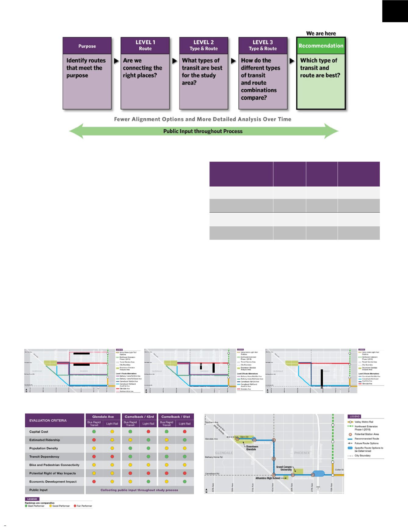
How are decisions made for routes through cities
and across city boundaries?
Valley Metro is an inter-city agency set up in 1993 as
the regional public
transportation agency providing coordinated, multi-modal transit options
to residents of greater Phoenix.
Valley Metro provides management for planning, building and
construction and subsequent operation of Light Rail as a collaboration of
cities in the Valley of the Sun through which light rail operates and serves.
The Valley Metro Light Rail system is an ongoing development that is
broken into phases with phases subsequently broken into geographic and
project segments.
Valley Metro gets input frommember cities, engineers, economic
planners, transit planning specialists, and most importantly the public.
Public input opportunities are numerous through the planned Light Rail
service area with community meetings held in all the phases of planning
and construction for light rail segments. For this segment of Light Rail,
116 public outreach activities have been held in the Valley including
community centers, schools, Village Planning Committees, and City
Council meetings.
Public meetings (10), events (22), presentations (41 )and surveys (7)
have taken place for this route locating process to extend Light Rail to
downtown City of Glendale that include proposed alignments in the City
of Phoenix and the Canyon Corridor.
The proposed route selections started with many alternatives (see below)
and was narrowed down through the public outreach along with research
on potential ridership, capital cost, population density, transit dependency/
usage, bike and pedestrian connectivity, potential right-of-way impacts
and a high emphasis on public input. The public and planner input has
narrowed the proposed alternatives to a leading alternative Light Rail
Route* extending fromCamelback Rd. at 19th Ave., west to 43rd Ave,
north to Glendale Ave. and west to 51st Ave, north to Glenn Dr. and west
on Glenn Dr.
— continued next page
Level 1 Route Alternatives
Level 2 Route Alternatives
Level 3 Route
Alternatives
Recommended Light Rail Route
30
Recommended Light Rail Route
30
* Leading Alternative Light Rail Route
Level 3 Evaluation Summary
20
Level 3 Evaluation Summary
Estimated Ridership
Estimated Ridership
Route
Project length
Glendale Ave
5.0 miles
Camelback/
43
rd
Ave
7.0 miles
Camelback/Grand/
51
st
Ave
6.4 miles
Weekday riders (light rail)
5,240
8,250
7,910
Weekday riders per project mile
(light rail)
1,050
1,180
1,240
Weekday riders (bus rapid
transit)
2,980
4,690
4,510
Weekday riders per project mile
(bus rapid transit)
600
670
700
21
Communi t y Highl ights
NorthernAve.
GlendaleAve.
BethanyHomeRd.
CamelbackRd.
51st Ave.
43rd Ave.
35 Ave.
27th Ave.
I-17 Freeeway
51stAve.
43rdAve.
35Ave.
27thAve.
I-17Freeeway
51stAve.
43rdAve.
35Ave.
27thAve.
I-17Freeeway
51stAve.
43rdAve.
35Av.
27thAve.
I-17Freeeway
5A .
h
GlendaleAve.
BethanyHomeRd.
CamelbackRd.
GlendaleAve.
CamelbackRd.
Camelback Rd.
Glendale Ave.
GrandAve.
GrandAve.
GrandAve.
GrandAve.
Northwest Extension
Now Open (2016)
CityofPhoenix
CityofGlendale
CityofGlendale
CityofPhoenix